


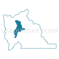
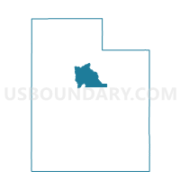
Utah Lake Voting District, Utah County, Utah
About
Outline

Summary
| Unique Area Identifier | 680226 |
| Name | Utah Lake Voting District |
| County | Utah County |
| State | Utah |
| Area (square miles) | 139.21 |
| Land Area (square miles) | 0.15 |
| Water Area (square miles) | 139.06 |
| % of Land Area | 0.11 |
| % of Water Area | 99.89 |
| Latitude of the Internal Point | 40.17647340 |
| Longtitude of the Internal Point | -111.80126690 |
Maps

Graphs
Select a template below for downloading or customizing gragh for Utah Lake Voting District, Utah County, Utah


Neighbors
Neighoring Voting District (by Name) Neighboring Voting District on the Map
- American Fork 2 Voting District, Utah County, UT
- American Fork 2 Split Voting District, Utah County, UT
- Benjamin - Lake Shore Voting District, Utah County, UT
- Elberta Unincorporated Voting District, Utah County, UT
- Genola 1 Voting District, Utah County, UT
- Lakeview Voting District, Utah County, UT
- Lehi 11 Split Part A Voting District, Utah County, UT
- Lehi 4 Voting District, Utah County, UT
- Lindon 1 Voting District, Utah County, UT
- Provo 17 Voting District, Utah County, UT
- Provo 18 Voting District, Utah County, UT
- Provo 19 Voting District, Utah County, UT
- Saratoga Springs 2 Voting District, Utah County, UT
- Saratoga Springs 3 Voting District, Utah County, UT
- Spanish Fork 7 Voting District, Utah County, UT
- Springville 2 Voting District, Utah County, UT
- Vineyard Voting District, Utah County, UT
Top 10 Neighboring County Subdivision (by Population) Neighboring County Subdivision on the Map
- Provo-Orem CCD, Utah County, UT (200,995)
- Lehi CCD, Utah County, UT (74,616)
- Spanish Fork-Payson CCD, Utah County, UT (73,527)
- Goshen CCD, Utah County, UT (3,501)
Top 10 Neighboring Place (by Population) Neighboring Place on the Map
- Provo city, UT (112,488)
- Lehi city, UT (47,407)
- Springville city, UT (29,466)
- Saratoga Springs city, UT (17,781)
- Lindon city, UT (10,070)
- Genola town, UT (1,370)
- Lake Shore CDP, UT (817)
- Palmyra CDP, UT (491)
- Vineyard town, UT (139)
Top 10 Neighboring Unified School District (by Population) Neighboring Unified School District on the Map
- Alpine School District, UT (284,505)
- Nebo School District, UT (119,571)
- Provo School District, UT (112,488)
Top 10 Neighboring State Legislative District Lower Chamber (by Population) Neighboring State Legislative District Lower Chamber on the Map
- State House District 56, UT (90,503)
- State House District 67, UT (42,669)
- State House District 64, UT (36,158)
- State House District 61, UT (36,117)
- State House District 58, UT (30,039)
Top 10 Neighboring State Legislative District Upper Chamber (by Population) Neighboring State Legislative District Upper Chamber on the Map
- State Senate District 13, UT (150,707)
- State Senate District 11, UT (137,882)
- State Senate District 14, UT (98,499)
- State Senate District 15, UT (84,373)
Top 10 Neighboring 111th Congressional District (by Population) Neighboring 111th Congressional District on the Map
Top 10 Neighboring Census Tract (by Population) Neighboring Census Tract on the Map
- Census Tract 101.09, Utah County, UT (6,936)
- Census Tract 101.11, Utah County, UT (6,815)
- Census Tract 22.01, Utah County, UT (4,972)
- Census Tract 101.12, Utah County, UT (4,884)
- Census Tract 101.13, Utah County, UT (4,725)
- Census Tract 22.05, Utah County, UT (4,129)
- Census Tract 101.06, Utah County, UT (4,105)
- Census Tract 22.04, Utah County, UT (3,688)
- Census Tract 22.07, Utah County, UT (3,604)
- Census Tract 106, Utah County, UT (3,510)
Top 10 Neighboring 5-Digit ZIP Code Tabulation Area (by Population) Neighboring 5-Digit ZIP Code Tabulation Area on the Map
- 84043, UT (49,030)
- 84003, UT (42,384)
- 84660, UT (37,995)
- 84601, UT (31,486)
- 84058, UT (30,540)
- 84045, UT (16,875)
- 84655, UT (10,547)
- 84042, UT (10,094)
- 84633, UT (1,048)